SeaChart
SeaChart FEEDBACK

Your feedback makes SeaChart better.

Share an issue, suggest a feature or tell us about a better price. We’re listening.

New post

Feedback

Pinned
S Pro
# 6-Month Update — Thank You for Your Continued Support! Another month has passed, and **SeaChart has now been available for approximately six months!** First of all, I would like to sincerely thank everyone who has downloaded, tried, and continued using SeaChart. As an independent developer, seeing people around the world using something I've built is incredibly encouraging. Your feedback, suggestions, and support continue to motivate me to improve the app. ## 📱 Development Progress Over the past month, I've released **6 app updates** and completed **one batch of marine chart updates**. These updates included bug fixes, performance improvements, and new features based on user feedback. Another important milestone is that **the SeaChart website is now officially live!** The project has successfully migrated from its previous subdomain, `marine.aitinytools.com`, to its new home: 🌐 **Official Website:** https://seachart.app 🗺️ **Online Marine Charts:** https://seachart.app/chart/ 💬 **Community Forum:** https://seachart.app/bbs The new website brings the community forum and online marine charts together under one domain, making it easier for everyone to access SeaChart's services and share their experiences. ## 🌍 Community Growth Over the past 30 days, **981 users from around the world have accessed SeaChart through the app.** It is exciting to see SeaChart gradually reaching users across different countries and regions. Although SeaChart is still a small and relatively young project, every new user and every piece of feedback means a lot to me. ## 📡 AIS Development I also have some good news regarding AIS! The AIS equipment I purchased for real-world testing has finally arrived, and **most of the AIS functionality testing and debugging is now complete.** Having actual AIS hardware allows me to test communication, data reception, and target information much more reliably than relying entirely on simulated data. I'll continue improving AIS stability and functionality in future updates. ## 🗺️ Marine Chart Updates — Temporary Pause Unfortunately, I also have some less encouraging news regarding marine chart processing. The original global chart dataset is approximately **32 TB**, and I've estimated that processing and preparing the next stages of the chart system may require approximately **40 TB of temporary storage space**. My current server infrastructure is simply not sufficient for this workload. To make matters worse, one of my existing server storage drives has failed after prolonged intensive workloads and has been sent back to the manufacturer for warranty repair. While waiting for the replacement and preparing additional storage capacity, I will need to **temporarily pause marine chart updates for approximately two months**. During this period: - Existing marine charts will remain available. - No new chart data updates are currently planned. - Chart download speeds may occasionally be slower than usual. I apologize for the inconvenience and appreciate your understanding. My priority is to keep the existing services running reliably while preparing the infrastructure required for future chart updates. Once the storage situation is resolved, I'll resume processing and releasing new chart data. ## 🍎 iOS Release Updates The iOS version is still progressing through Apple's App Review process. Recently, review times have become unusually long. In some cases, **a single submission has taken approximately two weeks just to receive feedback**. I'm not entirely sure what is causing these delays, and unfortunately, Apple's review schedule is outside my control. I'm continuing to respond to review requests and make any necessary adjustments. **Thank you to everyone waiting for the iOS version. I really appreciate your patience!** ## 💰 Project Expenses and Financial Support I also want to continue being transparent about the financial side of SeaChart. Here are the latest figures: - **Total personal investment:** Approximately NZD 85,000 - **Donations received this month:** NZD 0 - **Current paid subscribers:** 0 The total investment includes development hardware, servers, storage, marine chart data processing, AIS equipment, Apple hardware, software services, and other project-related expenses. Compared with last month's update, my total investment has increased from approximately NZD 70,000 to **NZD 85,000**. SeaChart remains an independently developed and self-funded project. Although there have been no new donations or paid subscriptions this month, I will continue developing and improving SeaChart as much as my time and resources allow. I want to emphasize again that **financial support is entirely optional**. Simply using SeaChart, reporting bugs, suggesting improvements, or recommending it to others is already a meaningful contribution. ## 🎁 Upcoming SeaChart Pro Special Offer To celebrate SeaChart's first six months and thank everyone for their continued support, I'm preparing a **special promotion for the SeaChart Pro 6-month subscription**. The promotion will include an **18-day free trial of SeaChart Pro**, available to the first 200 users who redeem the offer. Both new and existing users are welcome to participate. I'll publish a separate announcement in the **SeaChart Community Forum** with the promotional code, redemption instructions, and full details. Please keep an eye on the forum if you're interested! 💬 https://seachart.app/bbs ## ⭐ A Small Request — Please Consider Leaving a Review If you enjoy using SeaChart and find it useful, I would really appreciate it if you could take a moment to **leave an honest rating or review on the app store**. As a small independent developer, I don't have a large marketing budget or a dedicated promotional team. Positive reviews and personal recommendations can make a real difference in helping more people discover SeaChart. And if something isn't working well, please don't hesitate to report it through the feedback system or community forum. **Every review, bug report, and feature suggestion helps me make SeaChart better.** ## ❤️ Thank You for Six Months of Support! Six months ago, SeaChart was just beginning its journey. Today, users from around the world are trying the app, sharing feedback, and helping shape its future. There are still many challenges ahead, especially with server infrastructure, global chart processing, and the iOS release. But I'm committed to continuing this project and making SeaChart more accurate, reliable, and useful. Thank you again to everyone who has downloaded SeaChart, tested new features, reported issues, shared suggestions, or simply continued using the app. **Your support means more than you might realize.** Here's to the next six months of SeaChart! 🚀
0 replies 1115 views
S Pro
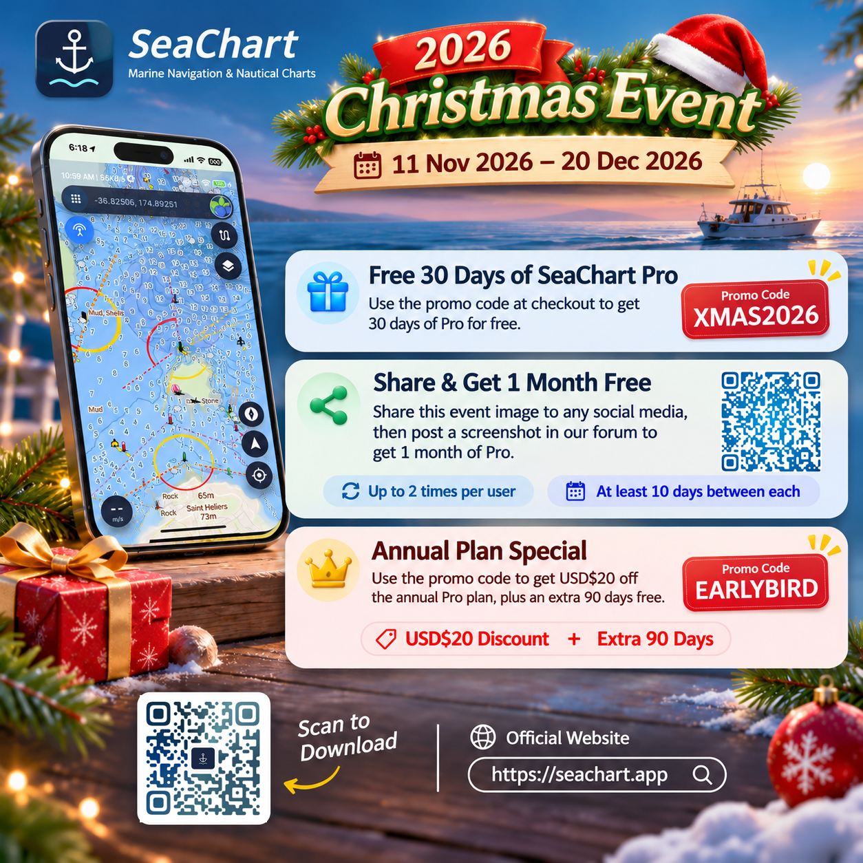
🎄 **SeaChart Christmas Giveaway 2026! 🎁** 🌊 **Enjoy up to 4 MONTHS of SeaChart Pro for FREE!** We're celebrating Christmas with some free Pro membership for everyone! 🎁 **Here's how to get your free membership:** ✅ **1 Month FREE** – Simply sign up for a SeaChart account. New users get at least 1 month of free Pro access! ✅ **+30 Days FREE** – Use promo code **XMAS2026** to claim another 30 days of SeaChart Pro! ✅ **+2 Months FREE** – Share this promotional image on any social media platform, then post a screenshot in our forum to receive 1 month of Pro for free. You can do this up to twice, with at least 10 days between submissions. That's **up to 4 months of SeaChart Pro for FREE!** 🎉 🎅 **Christmas Event: 11 November – 20 December 2026** We also have a special offer for annual memberships: use code **EARLYBIRD** to get **US$20 OFF + an extra 90 days FREE!** 📱 Download SeaChart: https://seachart.app/download/ 💬 Submit your sharing screenshot here: https://seachart.app/bbs?channel=feedback&moment=1056 🌐 Website: https://seachart.app 🎄 Feel free to share this with your boating, sailing and fishing friends. Merry Christmas and happy sailing! ⛵
Photos & videos
+
半 2 replies 167 views
Open
S Pro
Feedback from reddit user: Looks very nice, I see it is not new but already in its 2.5 release since May 2026. Browsing through it, I saw even the infamous Danish and Hong Kong waters are visible which is nice! Some lit aids to navigation are listed but without characteristics, mostly those with sectors. Why is that? I would like to know how you maintain the accuracy of the data. Do you crawl all open hydrographic notices to mariners? Do you share an API for allowing excerpts of your map for other webpages? Currently I use OpenSeaMap as one of the maps on my website in the detail page. Can users help in keeping the map up-to-date? You know crowd sourcing sometimes is more accurate than relying on shady maritime institutes. What is the database of the AtoNs? Some seem to be missing, see here left your SeaChart, right is OpenSeaMap https://imgur.com/a/iW5pTQx (54.49612, 8.66611) Copied from https://www.reddit.com/r/Nautical/comments/1xbg6gp/im_building_seachart_a_marine_chart_app_for/
+
0 replies 483 views
Open
S Pro
Implement AI-Based Fishing Catch Photo Moderation **Description:** Implement an automated photo moderation system for SeaChart using a lightweight local vision model via Ollama. The system should analyse user-uploaded photos and determine whether they are related to fishing catches. **Requirements:** - Use a lightweight vision model (Qwen3-VL 2B). - Automatically analyse uploaded photos. - Classify images into three categories: - **Approved:** Clearly shows a fishing catch (fish, crabs, lobsters, etc.). - **Rejected:** Unrelated content (scenery, boats, fishing gear, etc.). - **Manual Review:** Unclear or uncertain images. - Return structured JSON results with classification and reason. - Support multiple photos per submission. - Log moderation results for debugging and review. **Acceptance Criteria:** - Fishing catch photos are correctly identified. - Unrelated photos are flagged or rejected. - Uncertain images are sent for manual review. - The moderation system runs locally without relying on paid external AI APIs.
0 replies 895 views
Released
S Pro
# Enable satellite-aware connectivity in SeaChart and trial Starlink Direct to Cell internet access ## Goal Enable SeaChart to attempt lightweight internet access over carrier-provided satellite networks, including Starlink Direct to Cell where supported by the user's device, carrier and plan. Use shared Android/iOS network capabilities rather than carrier-specific business logic. This does not add a satellite subscription, enable global offshore coverage, or guarantee carrier approval. Starlink terminal Wi-Fi is treated as ordinary Wi-Fi unless the operating system explicitly reports a restricted path. ## Requirements - Detect satellite/ultra-constrained network conditions on supported Android and iOS versions and report them to Dart through Pigeon. - Prohibit raw AIS/NMEA uploads over satellite, including previously queued messages and fallback upload paths. - Prohibit chart and weather-package downloads over satellite, including multipart downloads and transfers started before a network change. - Allow point-weather queries over satellite using the platform HTTP stack, with a 20-second total HTTP timeout and no increase in the configured timeout. - Keep offline charts, GPS positioning, local AIS reception/display and local alarms operational. - Do not bind the entire application to satellite or disrupt the boat's local AIS Wi-Fi connection. - Add Android satellite opt-in and the relevant iOS map/weather app categories. Do not claim iOS optimization certification before validation.
+
S 1 reply 451 views
S Pro
# 🌍 SeaChart Connect Global eSIM — Coming Soon! **Stay Connected Worldwide. Pay Less. Enjoy More!** We're excited to announce that **SeaChart Connect Global eSIM is coming soon!** 🎉 Whether you're travelling abroad, on a business trip, or sailing across international waters, our goal is to make global mobile connectivity simpler, more flexible, and more affordable. ## 💙 Our Mission: Making Global Connectivity More Affordable! To bring you the best possible prices, we've been actively working with multiple international eSIM providers, comparing data plans, network coverage, pricing, and service quality across the globe. **Our goal isn't just to offer eSIMs — it's to become one of the most affordable and trusted choices for staying connected worldwide.** ## ✨ What's Coming? - 🌐 **Coverage in 200+ Countries and Regions** — Stay connected across Asia, Europe, the Americas, Oceania, Africa, and beyond. - 💰 **Highly Competitive Prices** — By working with multiple providers and continuously negotiating better rates, we aim to offer more data for less. - 📱 **No Physical SIM Required** — Install your eSIM quickly on compatible devices without replacing your existing SIM card. - 📦 **Flexible Data Plans** — Choose from single-country, regional, and global plans to suit your travel needs. - ♾️ **More Ways to Stay Connected** — Choose between fixed-data plans and daily unlimited plans that keep you connected at reduced speeds after your daily high-speed allowance is used. - 🔄 **Easy Top-Ups** — Selected plans support additional data or extended validity without requiring a new eSIM. - 📡 **Hotspot Sharing** — Share your mobile connection with laptops, tablets, and other devices. - 🛡️ **Flexible Refund Options** — Eligible plans can be refunded before activation, giving you greater peace of mind when planning ahead. - 🚀 **Regular Plan Updates** — We'll continuously explore new providers and better deals to keep our plans competitive. ## 👑 Exclusive PRO Price Matching **Found a cheaper eSIM plan elsewhere? Let us know!** We want SeaChart Connect PRO members to enjoy some of the most competitive eSIM prices available. If you find a publicly advertised, comparable eSIM plan at a lower price from another provider, simply share the provider's name and a public link to the offer through our Feedback Centre. We'll review the plan's data allowance, validity, coverage, and other relevant conditions, then work with our suppliers to **do our best to match or beat the price!** Every price comparison you share helps us negotiate better deals and potentially make global connectivity more affordable for everyone. ## 💳 A Simpler, More Transparent Buying Experience We believe buying an eSIM should be as easy as purchasing a regular mobile data plan. We'll aim to clearly display each plan's data allowance, validity period, supported destinations, activation rules, and refund conditions before you purchase. Many plans allow you to buy in advance, with the validity period starting only when your eSIM first connects to a supported network at your destination — perfect for planning your trip ahead of time. **For eligible plans that haven't been activated, we'll offer a straightforward refund request process.** Please note that some plans become active immediately upon purchase or installation and may not be refundable. Specific activation and refund conditions will always be provided before checkout. ## 🚀 Get Ready to Connect! SeaChart Connect is preparing for launch, and we'll be announcing our initial destinations, available data plans, and official launch date soon. We'll continue listening to your feedback, expanding our coverage, improving the experience, and working hard to make global mobile connectivity more affordable. **Making global connections easier. Making mobile data more affordable.** Thank you for your continued support and trust in SeaChart! 💙 **SeaChart Connect — Connect the World, Pay Less.** 🌊
+
0 replies 455 views
Announcement
S Pro
## 🎁 Special Offer – Get 18 Extra Days of SeaChart Pro! Thank you all for continuing to use SeaChart and for your amazing support! As a token of appreciation, I've created a special promotional code for the **SeaChart Pro 6-month subscription**. 🎁 **Promo Code:** `6MONTHOFFER` **What does this offer include?** Redeeming this code gives you **18 additional days of SeaChart Pro access**. - **Existing Pro users:** Extend your Pro access by an extra 18 days. - **New users:** Enjoy 18 days of Pro access through this promotional offer. **Please note:** This promotion provides **18 extra days of Pro access, not a free 6-month subscription**. Any subscription charges and renewal terms will be shown during redemption. **How to Redeem:** 1. Open SeaChart. 2. Go to **Manage Your Account → Redeem a Code**. 3. Enter `6MONTHOFFER`. 4. Claim your **18 extra days of SeaChart Pro!** 📅 **Promotion Period:** October 25–31, 2026 (UTC) 👥 **Limited to the first 200 users!** ✅ **Open to everyone!** Both new and existing SeaChart users are welcome to redeem this offer. This special promotion is my way of thanking everyone for their patience, feedback, and continued support. Your support means a lot to me and helps keep SeaChart growing! **Thank you for being part of the SeaChart community!** ❤️
0 replies 1128 views
Announcement
S Pro
# SeaChart Community Forum & Online Marine Charts Are Now Live! I'm excited to announce that the **SeaChart Community Forum and Online Marine Charts are now officially live!** You can now explore SeaChart's web services, access marine charts, share your experiences, and connect with other members of the community. 🌐 **Official Website:** https://seachart.app 🗺️ **Online Marine Charts:** https://seachart.app/chart/ 💬 **Community Forum:** https://seachart.app/bbs ## What's New? **Online Marine Charts** Explore marine charts directly on our website. Global chart data is being updated progressively, with more regions and higher-resolution coverage planned for the future. **Community Forum** Join the SeaChart community to share your boating and fishing experiences, exchange ideas, report issues, and suggest new features. **More Features Coming** I'm continuing to improve SeaChart, including exploring automatic marine route planning based on water depth and navigation information. ## Thank You for Your Support! **Visit https://seachart.app and explore what's new!** For the best mobile experience, continue using the **SeaChart app**. Thank you for being part of the SeaChart community!
+
0 replies 1225 views
Closed
P Pro
4 Month Update — Thank You for Your Support Another month has passed, and the app has now been available for approximately four months. During this update cycle, I have focused on a single major Android release, mainly improving and optimizing AIS-related features. This update is nearly ready and will be released soon. To properly test these features, I have also made a significant investment in purchasing real AIS equipment. Although I still do not own a boat, I am doing everything I can to create a realistic testing environment and ensure that the AIS functionality works reliably in real-world conditions. I expect to complete this round of AIS testing by mid-September. At the same time, I am urgently working on the development and release of the iOS version of the app. As much of my available development time is currently going into bringing the app to iPhone and iPad users, Android updates and responses to some feature requests may be slightly slower than usual during this period. However, Android development and maintenance are continuing, and I remain committed to supporting and improving both versions. Developing and maintaining this app requires a significant amount of time and ongoing expenditure on chart data, servers, development equipment, AIS testing devices, Apple development hardware, testing, and other related services. So far, the total amount I have personally invested in the project has exceeded NZD 45,000. The donation feature has now been available for some time, but the total amount received in donations remains NZD 0. Donations are, of course, completely optional. There are currently no mandatory paid features in the app, and I do not want anyone to feel pressured by this announcement. Simply using the app, providing useful feedback, and seeing it improve over time is already a form of support. However, I have noticed that the app occasionally receives low ratings on Google Play without any explanation or feedback. For an independently developed app with a relatively small user base, every rating has a significant impact on its overall score. A low rating without an explanation may discourage many potential users from even giving the app a try. Therefore, if you are satisfied with the app and feel that it has been useful to you, I would sincerely appreciate it if you could take a few seconds to leave a five-star review on Google Play. For you, it may only be a quick tap. But for a small app that is independently developed and continuously maintained, your review can greatly improve its visibility. More importantly, it lets me know that the considerable time, effort, and resources invested in this project are being noticed and appreciated. If you experience any problems, please consider reporting them through the app before leaving a low rating. Most issues can be investigated and resolved through communication and future updates, and I would truly appreciate the opportunity to understand and fix the problem. When submitting feature requests, please create a separate post for each request. This makes it much easier for me to track, manage, respond to, and follow up on every suggestion. I cannot promise that every request will be completed immediately, especially while I am working intensively on the iOS release and AIS testing. However, I carefully read all feedback and will continue doing my best to maintain and improve the app. Thank you to everyone who continues to use the app, report issues, share suggestions, and offer encouragement. If you would like to support the continued development of the app, you may choose to make a donation. If donating is not convenient, leaving a five-star review, sharing your genuine experience, or recommending the app to someone who may find it useful would also be incredibly valuable. Thank you again for your continued support and patience.
+
B 1 reply 1195 views

New post

Sign in